Achill Archaeological Field School, Deserted Village Project
The Deserted Village project
"No one knew enough to relate when and why the village was forsaken" (Heinrich Böll, The Irish Journal, 1957)
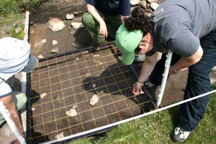
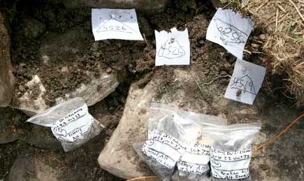
The Deserted Village Project commenced in 1991 with the research objective of completing a thorough archaeological survey of all sites and monuments (prehistoric and historic) that make up the diverse and significant archaeological landscape of Slievemore. Excavation of selected dwellings and their associated gardens has been an integral part of the fieldwork since 1991, and represents a pioneering effort at addressing the material lives of a much neglected segment of Irish society in a period often overlooked or dismissed by archaeologists. Additionally, over 1000 students from around the world have been introduced to archaeological field methods, accompanied by rigorous instruction in all periods of Irish archaeology.
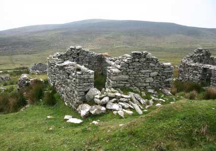
The Deserted Village is located on the southern slopes of Slievemore Mountain, Achill Island. The settlement straddles the 200 foot contour and stretches from west to east for about 1.5km. Three villages make up the settlement, linked by an ancient pathway. Today, access to the village is via a relatively recent trackway (1914), south of the modern graveyard at Slievemore. Eighty-four houses remain out of 137 which were recorded on the first edition Ordnance Survey of 1838. Over 90% of the houses are aligned north-south, parallel to each other and fall into three categories - single chambered, two-chambered and a single chamber with an outhouse or stable attached. A majority of the houses at Slievemore are one-roomed cabins, called 'byre-houses' because of the practice of keeping livestock indoors during winter. A channel separated the human area from the byre area and this type of dwelling was the prototype of the classic three-roomed house that can still be seen in most Achill villages.
Associated with the village are extensive lazy-bedfield systems, an agricultural method suited to the sloping hillside at Slievemore where water coursing downhill would drain away in the furrow separating the potato beds. The farming system at Slievemore was known as 'Rundale', a system of joint ownership of detached areas of land: each family had their holding of arable land scattered amongst those of the neighbours. Associated with 'Rundale' was the practice of 'booleying' where livestock were moved to mountain grazing during the growing season so that crops could mature undisturbed
Analysis of the ceramic material from the excavations at Slievemore suggest an occupation date commencing no earlier than 1750 and ending with the desertion sometime in the 1850s, although the village continued to be used on a seasonal basis into the 1940s. While the village was not abandoned during the Great Irish Famine (1845-1850), this catastrophic event reduced the overall population of Achill Island by 16%, from 4901 in 1841 to 4075 in 1851. An increase in rent, the impoverishment of land and the availability of grants for fishing boats led the remaining population at Slievemore to move to Dooagh where their descendents still live.
The environment and landscape of Slievemore Mountain, at 2,214 feet the highest peak on Achill Island, has long attracted human settlement. Ample evidence for Neolithic activity can be found in the remains of a series of court and portal tombs situated on the southern and eastern slopes of Slievemore in the townlands of Dugort West, and Keel East. Possible evidence for Neolithic agricultural activities can be traced on the slopes north of the post-medieval village in the collection of pre-bog field boundaries, some of which extend nearly as high as the western ridge top of the mountain. Similarly, Bronze Age activity on the mountain may be reflected by these field systems, and by several enigmatic round hut sites. Iron Age activity on Slievemore, assuming there was any, has left no physical trace as yet recognised. Early medieval and medieval activity, by contrast, is supported by the probable antiquity of the Slievemore graveyard with the presence of an equal armed cross and the remains of a church of possible early medieval provenance.
Today, the Achill Archaeological Field School is investigating the material traces left by all those who lived on the mountain, from the Neolithic farmers who built their field walls and megalithic tombs 5,000 years ago, to the families who occupied the carefully constructed stone byre dwellings in the 19thcentury. Archaeology is a method of systematically investigating the physical traces of the past which helps us to reconstruct and appreciate the experiences of those, like the Slievemore villagers, who may have left little documentary trace but whose lives continue to resonate in story, song, place, and memory.
Achill Archaeological Field School
Achill Folklife Centre
Dooagh, Achill Island
County Mayo
+353 98 43564
info@achill-fieldschool.com
www.achill-fieldschool.com
Sneak Peek
Some interesting items can be viewed here